Mersin is located in the Gulf of Mersin, a large body of water opening southwards onto the Mediterranean Sea. Mersin Port is close to the northernmost tip of the gulf and has been built on a coastline facing southeast. It is the main port for industry and agriculture in the Eastern Mediterranean Region. The port's rail connection and easy access to international highways make it an ideal transit port for Middle Eastern trade. Mersin is one of the important ports of the Eastern Mediterranean with its modern infrastructure and equipment, efficient cargo handling, extensive storage areas, and proximity to the free zone.
Cargo Handling
It handles general cargo, containers, dry and liquid bulk cargo, and ro-ro cargo.
Container Handling
The container terminal has five quays with a berth depth of 11.0 - 14.0m. The total length of the quays is 1,020m.
The container terminal covers an area of 251,350 m². The storage capacity of the container yard is 10,000 TEU (full and empty). Container handling operations at the terminal are carried out using 3 quay container gantry cranes with a capacity of 40 tonnes and 18 transloaders. There are 9 stackers with a capacity of 40 tonnes and 15 container forklifts with a capacity of 10-20 tonnes. There are 2 container loading stations with areas of 9,000 and 1,309 m². Another facility at the terminal is the provision of reefer facilities for refrigerated containers.
General Cargo Handling
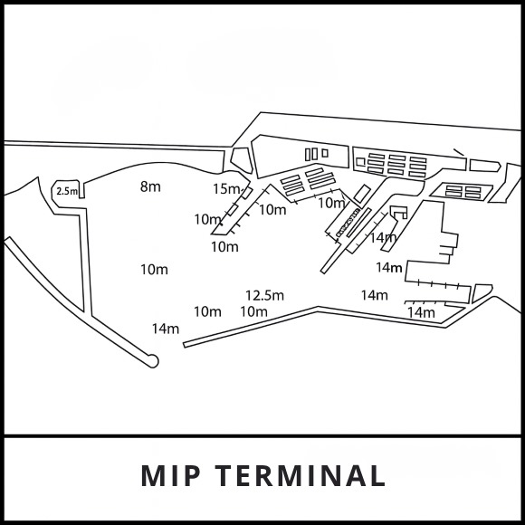
There are 11 quays with a total length of 1,572 m and depths ranging from 6 to 12 m. The quays and rear yard are well equipped with modern, high-performance cranes and handling equipment.
Bulk Cargo Handling
There are three quays with a total length of 708 m and depths ranging from 10 to 14.5 m. There is a reinforced concrete grain silo with a capacity of 100,000 tonnes, and a conveyor system connected to the quay. Loading speed: 1,200 x 2 = 2,400 tonnes/hour. Unloading rate: 600 x 2 = 1,200 tonnes/hour. Silo capacity 100,000 tonnes.
RO-RO Handling
There are ro-ro facilities in the port.
Railway Ferry
There is a ferry pier in the port. The terminal is 253 m long. Quay length and depth of 12 metres alongside. There are 10 km of shunting tracks behind the quays for marshalling wagons. However, the bridging system is not yet in place. Once the type of ferry to serve this route has been determined, the system will be put into service after being properly organised.
Free Trade Zone
There is a free trade zone next to the port. The zone covers an area of 776,800 m².
The activities in the zone are approximately 500 m long. The quays have a water depth of 8 m. Up to 10 m.
Quay
The port is protected by two breakwaters, 2,800 metres long and 1,525 metres wide. The depth at the entrance is 14 metres and 14.5 metres inside the breakwaters.
Anchorage Areas
General cargo vessels:
36º 42' N – 34º 38' E
36º 42' N – 34º 43' E
36º 46' N – 34º 43' E
36º 46' N – 34º 38' E
Dangerous cargo vessels:
36º 42' N – 34º 43' E
36º 42' N – 34º 47' E
36º 46' N – 34º 47' E
36º 46' N – 34º 43' E
Pilotage
Pilotage is compulsory for vessels entering or leaving the port or anchoring at the locations specified below. The service is provided by the Port Authority and is available 24 hours a day. VHF channels 16 and 12.
Tug
Four tugs are available, including at weekends, providing 24-hour service (one tug with 1500 hp, one tug with 2500 hp and two tugs with 3200 hp, and are provided by the Port Authority.